
Contact

 +49-9131-85-27775
 +49-9131-85-27270
Secretary
| Monday | 8:00 - 12:15 |
| Tuesday | 8:00 - 16:45 |
| Wednesday | 8:00 - 16:45 |
| Thursday | 8:00 - 16:45 |
| Friday | 8:00 - 12:15 |
Address
Lehrstuhl für Informatik 5 (Mustererkennung)
Martensstr. 3
91058 Erlangen
Germany
Powered by

Hyperspectral Remote Sensing Image Analysis
Remote sensing is nowadays of paramount importance for several application fields, including environmental monitoring, urban planning, ecosystem-oriented natural resources management, urban change detection and agricultural region monitoring. Majority of the aforementioned monitoring and detection applications requires at some stage a label map of the remotely sensed images, where individual pixels are marked as members of specific classes, e.g. water, asphalt, grass, etc. In other words, classification is a crucial step for several remote sensing applications. It is widely acknowledged that exploiting both the spectral as well as spatial properties of pixels, improves classification performance with respect to using only spectral based features.
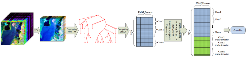
In this regard, morphological profiles (MP) are one of the popular and powerful image analysis techniques that enable us to compute such spectral-spatial pixel descriptions. They have been studied extensively in the last decade and their effectiveness has been validated repeatedly.
The characterization of spatial information obtained by the application of a MP is particularly suitable for representing the multi-scale variations of image structures, but they are limited by the shape of the structuring elements. To avoid this limitation, morphological attribute profiles (AP) have been developed. By operating directly on connected components instead of pixels, not only we are able to employ arbitrary region descriptors (e.g. shape, color, texture, etc.) but it paves the way for object based image analysis as well. In addition, APs can be implemented efficiently by means of hierarchical image representations, e.g. Max-/Min-tree and alpha-tree.
Although the aforementioned descriptors served well for spectral-spatial image description, they have their own bottlenecks. In this project, we investigate, study and propose new descriptors and methods for both spectrally and spatially describing the hyperspectral remote sensing images.
 |